

UK Snow Weather Forecast: When and Where Snow Will Hit
UK Snow Weather Forecast: When and Where Snow Will Hit
Snow in the UK has a unique way of changing the national mood. A single forecast can spark excitement, concern, and a rush to check travel plans all at once. That is why the UK Snow Weather Forecast attracts so much attention every winter. Snowfall in Britain is rarely uniform, often unpredictable, and highly dependent on small shifts in temperature and wind direction. Understanding when and where snow will hit is less about one dramatic prediction and more about reading patterns, probabilities, and regional differences.
Why the UK snow forecast is so closely watched
Unlike countries with long, stable winters, the UK sits in a transition zone between mild Atlantic air and colder Arctic or continental air. This makes the UK Snow Weather Forecast particularly sensitive. A change of one or two degrees can be the difference between rain, sleet, or disruptive snowfall. Moreover, even light snow can cause major travel disruption because infrastructure is not designed for prolonged icy conditions.
Snow as a high-impact weather event
Snowfall in the UK may be infrequent, but its impact is often outsized. School closures, road delays, airport disruption, and increased accident risk all follow quickly. That is why forecasts are monitored closely by authorities, businesses, and households alike.
Public trust in official guidance
Many people rely on updates from organisations such as Met Office to interpret the UK Snow Weather Forecast. These forecasts combine satellite data, computer models, and human expertise, offering guidance rather than guarantees.
How meteorologists predict snow in the UK
Snow forecasting is more complex than predicting rain. It requires several conditions to align.
Temperature profiles
Surface temperature is only part of the story. Meteorologists also look at temperatures higher in the atmosphere. For snow to fall and settle, cold air must extend through multiple layers.
Moisture and precipitation
Cold air alone does not produce snow. Moisture is essential. Weather systems moving in from the Atlantic often provide precipitation, but whether that falls as rain or snow depends on temperature structure.
Wind direction and air mass origin
The UK Snow Weather Forecast often hinges on wind direction. Northerly or easterly winds bring colder air from polar or continental regions, increasing snow risk, especially in eastern and northern areas.
Typical UK snow patterns by region
Snowfall is not evenly distributed across the country. Geography plays a major role.
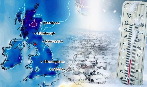
Scotland
Scotland is the most snow-prone region. Higher elevations, cooler temperatures, and proximity to Arctic air mean snow is more frequent and longer lasting. The UK Snow Weather Forecast often highlights Scotland first when cold spells approach.
Northern England
Northern England can experience significant snowfall, particularly over the Pennines. Eastern areas may also see snow showers driven by North Sea airflows.
Midlands
The Midlands sit on a boundary zone. Snow here depends heavily on how far south cold air penetrates. Marginal events often result in sleet or wet snow.
Southern England
Southern England is more likely to see snow during strong cold outbreaks. Coastal areas may stay milder, while inland locations have a better chance of accumulation.
Wales
Wales experiences varied conditions. Higher ground can see snow even when lowland areas receive rain. Wind exposure also influences snowfall distribution.
When snow is most likely to hit the UK
The timing of snow events follows seasonal patterns.
Early winter
November and early December snow tends to be short-lived and localized. Ground temperatures are often too warm for lasting cover.
Mid-winter peak
January and February are the peak months for snow risk. Cold air masses are more established, increasing the likelihood of disruptive events in the UK Snow Weather Forecast.
Late winter surprises
March snow is not uncommon, especially during northerly outbreaks. Although daylight increases, cold air can still produce snowfall.
Key weather setups that bring snow
Understanding common setups helps interpret forecasts.
Arctic northerlies
Air flowing directly from the Arctic can bring widespread cold and snow showers, especially to northern and eastern regions.
Easterly winds
Easterlies draw cold air from continental Europe. These setups often produce persistent snow showers along the east coast.
Battleground scenarios
When mild Atlantic air meets cold continental air, heavy snow can fall along the boundary. These situations are among the hardest to forecast accurately.
How much snow could fall
Snow depth is one of the most uncertain aspects of the UK Snow Weather Forecast.
Light snow events
Light snowfall may leave a dusting, enough to whiten landscapes but with limited disruption.
Moderate accumulations
Several centimetres of snow can cause travel issues, particularly during rush hour.
Heavy snowfall
Significant snowfalls are rare but impactful. These events usually require prolonged cold and steady precipitation.
Travel disruption and safety considerations
Snow affects more than scenery.
Roads and rail
Icy conditions reduce traction and increase accident risk. Rail services may face delays due to frozen points.
Airports
Even small amounts of snow can disrupt flight schedules due to safety requirements.
Personal safety
Walking on icy pavements increases injury risk. Preparation and caution are essential during snow events.
Preparing for snow at home
The UK Snow Weather Forecast is most useful when it informs preparation.
-
Check heating systems and insulation
-
Stock essential supplies
-
Monitor updates for changing conditions
-
Plan alternative travel arrangements if needed
Climate change and UK snowfall
Climate change complicates snow forecasting.
Warmer averages, sharper extremes
Overall winters are becoming milder, but extreme cold events can still occur. This leads to fewer snow days but potentially more intense snowfall when conditions align.
Increased unpredictability
The UK Snow Weather Forecast now deals with greater variability. Sudden temperature swings are more common.
Interpreting forecast uncertainty
Forecasts are not promises.
Probability-based thinking
Snow forecasts often use probabilities. A 30 percent chance of snow does not mean it will definitely snow, but it signals risk.
Updates and refinement
As weather systems approach, forecasts become more accurate. Regular updates are crucial during potential snow events.
Common misconceptions about UK snow forecasts
Snow maps as guarantees
Snow maps show potential outcomes, not certainty. They are best viewed as guidance.
One forecast fits all
Local geography means conditions vary widely, even within short distances.
Regional snow risk summary
| Region | Snow Risk Level | Typical Impact |
|---|---|---|
| Scotland | High | Frequent snow, longer duration |
| Northern England | Moderate to High | Hill snow, travel disruption |
| Midlands | Moderate | Marginal events, mixed precipitation |
| Southern England | Low to Moderate | Short-lived snow, urban impact |
| Wales | Variable | Upland snow, coastal rain |
How long snow usually lasts
In the UK, snow rarely lingers for weeks. Most snow events melt within days as temperatures rise. However, shaded areas and higher ground can retain snow longer.
The role of public behaviour
Public response influences impact. Early preparation reduces disruption. Understanding the UK Snow Weather Forecast helps individuals make informed decisions rather than reacting late.
Why snow forecasts still fascinate
Snow transforms familiar landscapes and routines. It disrupts normality in a way few other weather events do. That emotional response ensures the UK Snow Weather Forecast remains one of the most searched topics each winter.
Looking ahead: what to expect next
Rather than focusing on one date, it is better to watch trends. Cold signals in long-range models suggest potential, while short-range forecasts confirm details. This layered approach offers the clearest picture.
Final thoughts on the UK snow outlook
The UK Snow Weather Forecast is about managing expectations. Snow in Britain is rarely straightforward, but understanding the factors behind it makes forecasts more meaningful. By following updates, recognizing uncertainty, and preparing sensibly, individuals can navigate winter conditions with confidence. If you found this breakdown helpful, share it with others or comment on how snow typically affects your area.